Search results
Pages
-
-
Title
-
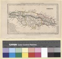
Jamaica (1834)
-
Summary
-
Steel engraved 1834 map of Jamaica from the Montgomery Martin's History of the British Colonies Vol. 2 West Indies Counties appearing on the map: Cornwall, Middlesex, and Surrey. Parishes appearing in Cornwall: Hanover, Westmorland, and St. Elizabeth. Cities appearing in Cornwall: Hanover: Lucea, Montego Bay, and Trelawney (?). Westmorland: Savannah la Mer (Savanna-la-Mar), Queen's Town (?), and Blewfields (Bluefields). St. Elizabeth: Accompong Town (Accompong) and Lacovia. Parishes appearing in Middlesex:Trelawney, Manchester, St. Ann, Clarendon, Vere, St. Dorothy, St. John, and St. Catherine. Trelawney: Martha Brea (Martha Brae), Falmouth, and Rio Bueno. Manchester: No Cities. St. Ann: St. Ann's Bay. Clarendon: The Cross (Palmers Cross) and Chapleton (Chapelton). Vere: The Alley (?). St. Dorothy: Old Harbour (?). St. John: No Cities. St. Catherine: Spanish Town. Parishes in Surrey: St. Mary, St. George, Portland, St. Thomas in the East, St. David, and Kingston. St. Mary: Ora Cabessa R & B (Oracabessa) and Scots Hall Town (?). St. George: Anotta Bay (Annotto Bay). Portland: Port Antonio and Moore Town. St. Thomas in the East: Bath, Port Morant, and Morant Bay. St. David: No Cities Kingston: Stony Hill, Halfway Tree (Part of Kingston, Half Way Tree Road), Kingston, and Greenwich (Greewich Town is now part of Kingston). Written on the lower left corner of the map is the following information about the island: Length: 160 miles Breadth: 45 to 50 miles Division-3 Counties-21 Parishes Seat of Govt. Spanish Town Annual Revenue ₤300,000 Do. Maritime Commerce Value: ₤6,000,000 Highest Land: 8,000 Feet Discd. by Columbus: A.D. 1494 Colonized by Spain: A.D. 1509 Captured by England: A.D. 1655 Population: Whites 35,000, Coloured: 450,000 Mapmakers: John Walker, Alexander Walker and Charles Walker, known collectively as J & C Walker (active 1820-95), were engravers, draughtsmen and publishers working through the 19th century.
-
-
Title
-
Popular hymns no. 3: popular songs and standard hymns, suitable for the Bible school, church services..., Popular hymns number 3, Songs of hope : for the church and Sunday School / compiled and edited by E.O. Excell printed in round and shaped notes with orchestration, Songs of the century for missionary and revival meetings, Sabbath schools and young people's societies / edited by Geo. D. Elderkin, Jno. R. Sweney, Wm. J. Kirkpatrick, H.L. Gilmour, and F.A. Hardin, Songs of the king / [compiled by Charles Reign Scoville], Sunday school voices no. 2 : a collection of sacred songs / music editor Chas. H. Gabriel, The tabernacle hymns / edited and compiled by D.B. Towner and Arthur W. McKee, Treasury of song : songs for all religious gatherings / edited and compiled by Robert H. Coleman, Truth in song : for general Gospel work / edited by B.E. Warren ... [et al.], Twentieth century songs. Part one : a collection of new and popular songs with standard hymns for church, Sunday school, young people's societies and special services / edited by Chas. H. Gabriel, J.E. Hawes and W.E.M. Hackleman, 20th century songs, Victory songs, Victory songs : for the church, Sunday school and evangelistic services / Homer A. Rodeheaver, compiler Chas. H. Gabriel, music editor, Victory songs : for the church, Sunday school and evangelistic services / Homer A. Rodeheaver, compiler Chas. H. Gabriel, music editor, Waves of glory, no. 2 / edited by W.J. Kirkpatrick, D.L. Wallace, C.J. Kinne, Windows of heaven : hymns new and old for the church, Sunday school and home / compiled by H.M. Wharton, Winona hymns / compiled by J. Wilbur Chapman edited by E.O. Excell for the Evangelistic Committee, Wonder hymns of faith : a new general-purpose song-book / compiled by Chas. R. Scoville, W.E.M. Hackleman, J.E. Sturgis, orchestration by J.C. Blaker, responsive readings selected by E.E. Violette, The world evangel : the brightest and best songs for all religious gatherings / edited and compiled by Robert H. Coleman, World wide revival songs, number two : for the church, Sunday school and evangelistic campaigns / James G. Garth, compiler Albert C. Fisher, editor assistant compilers, Harry Dixon Loes ... [et al.] by order of the International Federation of Christian Workers, The young people's hymnal : adapted to the use of Sunday schools, Epworth Leagues, prayer meetings, and revivals / by W.D. Kirkland, James Atkins, William J. Kirkpatrick, The young people's hymnal, no. 2. Adapted to the use of Sunday schools, epworth leagues, prayer meetings, and revivals. By James Atkins, and William J. Kirkpatrick, The young people's hymnal No. 3 : adapted to the use of Sunday Schools, Epworth Leagues, prayer meetings, and revivals / by James Atkins and William J. Kirkpatrick
-
Date
-
[c1910], 1910, 9999, 9999, 9999, 9999, 9999, 9999, 9999, 9999, 9999, 9999, 9999, 9999, 9999, 9999, 9999, 9999, 9999, 9999, 9999, 9999
-
-
Title
-
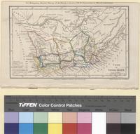
Cape of Good Hope (1835)
-
Date
-
1835-01-01, 1835
-
Summary
-
Steel engraved 1834 map of The Cape of Good Hope from Montgomery Martin's History of the British Colonies Vol. 4 Possessions in Africa & Australasia. Cities appearing on the map: Cape: Capetown (Cape Town). Stellenbosch: Stellenbosch. Clanwilliam: Clanwilliam, Papkuils (?), Leeuwenkuil (?), Droeg Kr. (?), Schuit (?), and Lily Fn. (?). Swellendam: Caledon, Swellendam, and Zuurbrak (Suurbraak). Worcester: Worcester and Tulbagh. Beaufort: Beaufort (Beaufort West) and Karreebosoh (?). George: George Tn. (George) and Elandsrug. Uitenhage: Bethelsdorf (Bethelsdorp), Uitenhage, Hartebeest (?), and Enon. ?: Graaf Reynet (Graaff-Reinet). Albany: Graham Tn. (Grahamstown), Bathurst, and Fredericksburg (?). Somerset: Somerset T. (?) and Cradock. Namaqua-Land: Rhenoster F. (?), Africananders Kr. (?), Orlam Kr. (?), Konnah (?), Riizos Kr. (?), Hardcastle Kloof (?), Griqua or Klaarwater (?), Phillipolis Miss. Sn. (?), Letaka (?), Tureehee (?), Campeldorp (?), Bootschap (Boetsap), Kouna (?), Koning F. (?), Plattenburg (?), Moos (?), Mobatee (?), Hart Kr. (?), Litakou (?), Kruman or New Litakou (Kuruman), Maquassa (?), Gaikas Kr. (?), Khanvees Kr. (?), Tzatzoe (?), Vosanis Kr. (?), Matuana Kr. (?), Omjutas (?), and Mahaks Kr. (?). Written on the lower left corner of the map is the following information about the Cape of Good Hope: Discovered: 1487 English formal occupation: 1620 Dutch Colonization: 1650 British Conquest: 1795 Restoration to Dutch: 1803 Recapture by British: 1806 Area of Territory: 200,000 Sq. Miles Population: 150,000 Mapmakers: John Walker, Alexander Walker and Charles Walker, known collectively as J & C Walker (active 1820-95), were engravers, draughtsmen and publishers working through the 19th century.
Pages